Cebu’s Tropical Climate and The Monsoons

Charting a dive expedition through the Philippines demands a sharp read of atmospheric mechanics. Cebu sits roughly ten degrees north of the equator; its oceanography ignores the traditional four-season calendar entirely. Shifting trade winds, deep equatorial currents, and seasonal monsoons dictate the marine environment. Timing your arrival to sync with these cycles becomes the defining factor in securing safe boat crossings, manageable surface intervals, and crystalline underwater visibility. Scoping out the foundational logistics on our Scuba Diving in Cebu homepage establishes the necessary baseline for an archipelago-wide itinerary.
The Philippine Atmospheric, Geophysical and Astronomical Services Administration (PAGASA) tracks the country’s climate across two massive meteorological phases: the Northeast Monsoon and the Southwest Monsoon. This pendulum swing controls ocean behavior throughout the Visayas. Wind direction alone decides which coastlines absorb punishing two-meter swells and which coastal stretches lie flat. Reading these seasonal shifts allows technical divers and recreational photographers to pinpoint the exact weeks when the outer shoals open up—and when terrestrial runoff inevitably blinds the inner reefs.
Amihan vs. Habagat: What Divers Need to Know
The Cebu diving calendar fractures along the fault line of the Amihan and the Habagat. Grasping the physical force these monsoons exert on the ocean surface remains vital for locking in the right dive operator and coastal region.
The Amihan Season (November to May)
The Amihan, or Northeast Monsoon, drags cooler, denser air down from the Asian continent. Sweeping across the islands from November through late April or early May, this system strips humidity from the atmosphere and starves the region of rain. Persistent northeast winds batter the eastern seaboard of Cebu—including parts of Mactan—whipping up choppy surface conditions and moderate swells. Protected by the central mountain range, the western coastlines turn to glass. Topside drought sparks the peak tourist rush. Below the surface, marine life flourishes; plunging water temperatures routinely trigger distinct pelagic hunting behaviors along the dark drop-offs.
The Habagat Season (June to October)
The Habagat, or Southwest Monsoon, seizes control from June to October. Pulling warm, moisture-laden air across the Indian Ocean and the South China Sea, the system blankets the island in oppressive humidity and violent rain squalls. The wind simply reverses course. The western coasts absorb the brunt of the surface chop; the eastern shores slip into the leeward shadow. Water temperatures hit their annual ceiling. Offshore boat rides turn rough under the unpredictable sky, yet the submerged environment remains spectacular. Muck diving ignores the monsoon entirely—you can dissect the benthic ecosystem in our Mastering Macro guide, noting that species like the blue-ringed octopus hunt completely indifferent to the storms raging above.
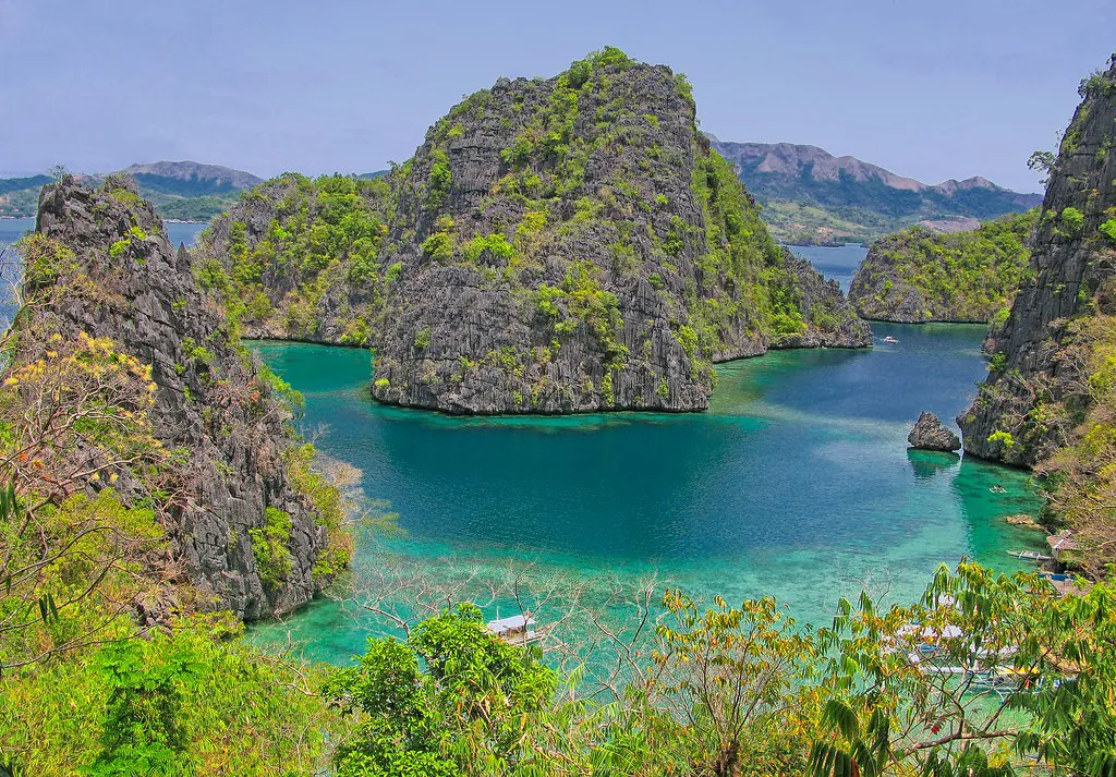
Map of Cebu’s Dive Spots & Seasonal Accessibility
Stretching over 225 kilometers from north to south, Cebu forms a long, narrow barrier against the sea. This sheer geographical length guarantees a leeward side exists somewhere on the island. While Amihan winds hammer the northern tip near Malapascua, the southwestern coasts near Moalboal sit in total shelter. The geographical data mapped above helps isolate the most resilient dive sectors based on your exact arrival month.
March to June opens the ultimate logistical window for diving in Cebu. The trade winds drop, the Tañon Strait flattens into glass, and water temperatures climb to a comfortable 29°C, pushing visibility beyond 30 meters on the outer walls.
The Sweet Spot: March to June
Demanding pristine conditions narrows the calendar down to the transitional window from March through June—the undisputed apex of Philippine diving. The Amihan trade winds burn out long before the Habagat system marshals its strength. A profound meteorological lull settles over the Visayan Sea, characterized by a near-total absence of wind shear. Stripped of the relentless surface agitation that churns the water column, suspended particulates crash to the seabed. Divers logging descents along the steep drop-offs during these months routinely clock horizontal visibility past the 30-meter mark.
Glassy surfaces grant traditional outrigger boats (bangkas) immediate clearance to offshore sea mounts and distant shoals, sites typically sealed off by punishing swell. Weather-related cancellations practically vanish from the dive center whiteboards. Plotting excursions to deeply exposed sites becomes highly reliable; cross-reference our Where to Go directory to map the coordinates. Predictability breeds crowds, making this the peak operational quarter for local crews. Securing a tank rack requires booking well ahead of your flight. You can lock in these logistics through our Guided Tours & Lessons page. Capitalizing on the dead-calm Mactan channel, newcomers easily schedule a Scuba Diving Experience beach entry in Mactan, dialing in their buoyancy in pool-like conditions before graduating to deep-water boat drops.
Cebu Water Temperature & Wetsuit Guide by Month
Tropical thermal protection revolves around guarding your core body temperature through consecutive days of repetitive exposure. The surface air bakes, yet 60 minutes spent breathing compressed gas at 25 meters bleeds heat from the human body radically faster than air. The matrix below parses the average sea surface and at-depth temperatures across the Cebu province, dictating exactly which cut of neoprene belongs in your dry bag.
| Month Range | Average Water Temperature | Thermocline Probability | Recommended Wetsuit |
|---|---|---|---|
| January – February | 26°C – 27°C (79°F – 81°F) | High (Cool upwellings at 20m+) | 3mm to 5mm full suit |
| March – April | 27°C – 28°C (81°F – 82°F) | Moderate | 3mm full suit or 3mm shorty |
| May – June | 29°C – 30°C (84°F – 86°F) | Low (Uniformly warm column) | Rash guard or 1.5mm shorty |
| July – October | 28°C – 29°C (82°F – 84°F) | Moderate (Rain-induced surface mixing) | 3mm shorty |
| November – December | 27°C – 28°C (81°F – 82°F) | High (Slight drops below 15m) | 3mm full suit |
Neoprene crushes under pressure; a 3mm suit expanding at the surface yields far less insulation at 30 meters. Cross-check your packing list against our Equipment & Safety Guide before zipping the luggage. Divers running cold should default to a full-length 3mm suit—a barrier that also defends against stinging hydroids and the inevitable, accidental coral scrape.
Visibility, Typhoons, and Dive Safety
Tidal exchanges, deep-water upwellings, and terrestrial runoff dictate the erratic clarity of Cebu’s coastal waters. Intense, localized downpours during the Habagat season flush heavy sediment down the island’s interior rivers, dragging visibility well under 10 meters around the estuaries. Spiking ocean temperatures simultaneously ignite plankton blooms. A thick, emerald water column obscures the reef visually while acting as a vital biological engine; the nutrient-dense soup pulls in migrating pelagic species, turning the wall into a frantic feeding ground.
The typhoon belt introduces the most severe seasonal variable to the archipelago. Extreme tropical cyclones track across the Philippines, historically concentrating their destructive power between July and November. The United Nations Office for Disaster Risk Reduction (UNDRR) meticulously documents these atmospheric anomalies, highlighting the sheer devastation of Super Typhoon Yolanda (Haiyan) in November 2013. Yolanda leveled structural dive hubs across Malapascua, splintering bangkas and crushing shallow branching corals. Down deep, the reef architecture absorbed the impact and has since staged a total ecological recovery.
Atmospheric volatility overrides any planned dive schedule. The Cebu Provincial Government and the Philippine Coast Guard lock down the ports and enforce strict no-sail mandates the moment official storm signals drop. A looming low-pressure system grounds the fleet, forcing an immediate pivot in your itinerary. Repurpose these mandatory surface intervals by pushing into the island’s mountainous interior. Scanning our Other Things to Do in Cebu guide outlines hardened backup plans—routing you toward inland canyoneering at Kawasan Falls or through the centuries-old Spanish colonial architecture of Cebu City, miles away from the threat of storm surge.
Timing Your Dives: Malapascua, Moalboal, and Oslob
Pinpoint logistical timing governs the highest-profile marine encounters in Cebu, heavily restricted by local bathymetry and raw animal behavior. Up north, intercepting the offshore cleaning stations of Monad Shoal and Kimud Shoal forces a one-hour boat transit across the open strait from Malapascua Island. Peak Amihan winds in January and February turn this crossing into a brutal, physical ordeal. Outrigger crews battle deep-water swells in the pitch black. The March-to-June window flattens the ocean, transforming a punishing ride into a smooth dawn cruise. Catching the sharks requires leaving the beach under the stars. Studying our Thresher Shark Diving Guide decodes the rigid 5:00 AM departure protocols mandatory for intercepting *Alopias pelagicus* hunting at 30 meters.
The Tañon Strait grants Moalboal a massive geographic shield further down the coast. The towering volcanic spines of Cebu to the east and Negros to the west form an impenetrable windbreak, isolating the deep channel from atmospheric chaos. This extreme bathymetry leaves Moalboal’s vertical drop-offs accessible roughly 365 days a year. Conservation authorities like PADI point to Moalboal’s relentless sardine run as the baseline for a self-sustaining coastal ecosystem. Pushing depth limits along these walls requires specialized gas planning; diving into our Technical Diving resources lays the groundwork for drops to 45 meters, where the water column remains dead calm regardless of the surface chop above.
The Oslob whale shark interaction ignores macro-seasons entirely, operating instead on a ruthless micro-schedule. Wet Habagat or bone-dry Amihan, the timeline refuses to bend. Boats launch exclusively from 6:00 AM to 12:00 PM; the coast guard cuts off final water entries sharply at 11:00 AM. Mitigating biological stress on the animals requires capping individual interactions at exactly 30 minutes. Current municipal mandates lock environmental fees at 1,000 PHP for foreign passports and 500 PHP for locals. Hitting the briefing center by dawn remains the only tactic to outpace the massive convoy of tourists bleeding down from Cebu City, locking in a highly regulated, fleeting encounter with the largest fish in the ocean.